Case Study
ResiMod VUI: From Complex Model to Visual Interface
As part of the RESILIM-O programme, BTN worked with the Association for Water and Rural Development (AWARD) to make ResiMod—an expert system-dynamics model of the Olifants catchment—usable by non-specialists. The result is ResiMod VUI, a desktop application that lets people explore climate and management futures, run scenarios, and discuss trade-offs together.
ResiMod captures feedback loops among ecosystem, infrastructure and society. Although valuable, the model was difficult to share outside technical circles. We were engaged to design a standalone tool intended to facilitate exploration by municipal planners, educators, and civil society, while ensuring that relevant system-dynamics structures remain visible to practitioners. The tool needed to work offline on typical laptops and communicate results without requiring chart literacy.
We used a participatory, staged process—discovery workshops, rapid prototyping, and field testing—to converge on a product form that balances rigor and approachability. Early pilots helped determine what to simplify, what to reveal, and how best to communicate outcomes.
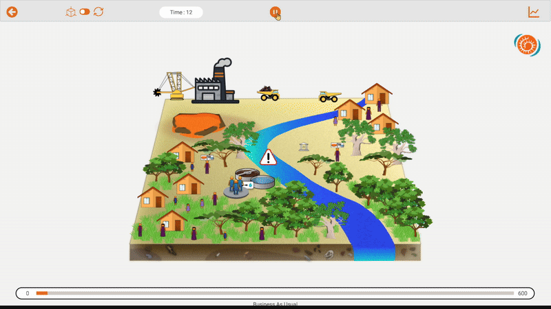
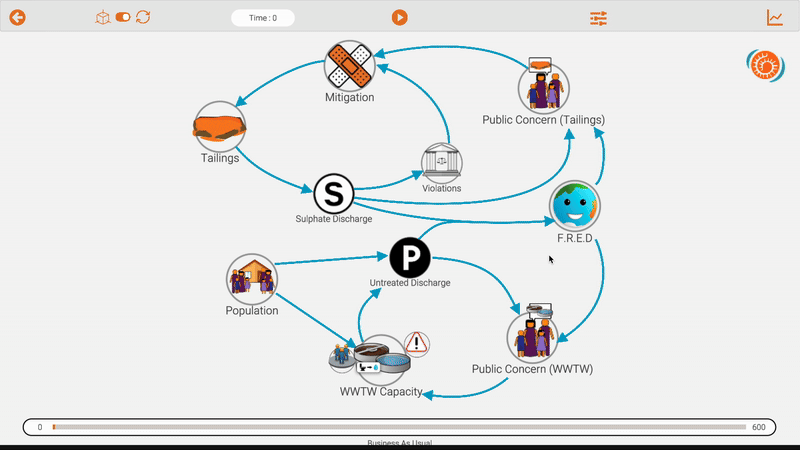
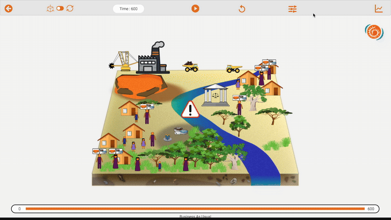
ResiMod VUI opens with a Scenario Library that presents preconfigured combinations of climate outlooks and management choices as large, readable tiles, allowing a useful run within seconds. Inside the Model interface, a single toggle offers two complementary ways to think about the system: a simplified, zoomable Causal Loop Diagram (CLD) that keeps structure and feedbacks visible to practitioners, and an approachable 2.5D landscape of the catchment—settlements, river segments, wastewater treatment works, vegetation, and a tailings dam—that helps newcomers reason spatially.
Running a simulation is intentionally straightforward: a prominent Play button starts the model, while a year counter and progress indicator provide pacing. Results appear visually through animations and through behavior over time graphs. A comprehensive control panel with key input sliders enables users to set up custom scenarios to run experiments and establish the basis for policy discussion.
We prioritized insight before detail, favoring immediate comprehension through indicators, timelines, and scenario tiles while leaving depth available through the CLD and progressive disclosure. BTN created visual icons from scratch, drawing on the local context to ensure the interface felt familiar and recognizably local. Accessibility and resilience guided sizing and contrast choices and shaped performance work. The application was tuned to remain readable at workshop distances, operate offline, and run smoothly on modest hardware.
The result is a tool that shortens onboarding to a first meaningful run and broadens participation by enabling diverse audiences to propose scenarios and interpret outcomes. At the same time, the CLD preserves the model’s structure for practitioners, while the behavior over time graphs provide a way to diver into deeper analyses.
Our sincere thanks to the Association for Water and Rural Development (AWARD) for their support throughout this work and Dr Jai Clifford-Holmes, whose expertise, guidance, and steady partnership were essential to the project’s success.